Bandhavgarh is a world famous national park for tiger photography and sighting. Here you can see tigers in their natural habitat, along with many other mammals, birds and reptiles. India's first white tiger was also found in this forest. It was a private hunting preserve of Baghela dunasty till 1968. Later hunting was declared offence and for tiger conversation, it was declared are national park followed by tiger reserve status.

Geographically Tiger Reserve forest is spread over Vindhya ranges that spread through Central India and constitute important forest belt sheltering varying variety of flora & fauna. Waterfalls in Vindhya ranges are scenic & popular for its evergreen nature. Vindhay & Satpura ranges are two important forest belts of Central India sheltering a major share of Indian Tiger's population.
How to reach:
Bandhavgarh Tiger Reserve is located in Umaria District of Madhya Pradesh State in India.
From Umaria: It is the nearest largest town connected by road, train and charter planes. Park is just 37kms/45mins from Umaria town.
From Jabalpur: Bandhavgarh is about 190kms from Jabalpur city. Their are 03 different ways to reach Bandhavgarh from Jabalpur i.e via Katni, via Sleemanabad and via Shahpura tribal town. Jabalpur have connectivity with Delhi & Mumbai by Flight and train connectivity with major cities like Agra, Jaipur, Mumbai, Hyderabad, Kolkata etc.
From Katni: This city is important railway junction and is about 100kms/02:30hrs from Bandhavgarh. One can travel by road from Katni to Bandhavgarh via Umaria or Barhi town.
From Khajuraho: It is at a distance of 250kms/05:00hrs is also well connected by road to Bandhavgarh.
Climate & Weather:
The climate of bandhavagrh is a north indian monsoonal. It is mainly characterised by well - defined winters, summers and rains. During the winters the mercury falls upto 2° C in the month of January and during the summers it goes upto 45° C. Average rainfall of 1133 mm, most of which pecipitates during the monsoons.
Best Time to Visit:
Bandhavgarh Tiger Reserve remains open from October to June months for visitors. So one can visit the park at any day during these months. In monsoon, i.e. in the months of July – August – September, Bandhavgarh Park remains closed for visitors.
In first two months, after opening of park, i.e. during October and November, climate remains pleasant as after monsoon departure, we can find greenery everywhere in the forest area with plenty of water-holes. Winter season lasts for 3-months in Bandhavgarh, December – January – February. March & April (first half) are the Spring seasons but day time temperature will make you feel hot as temperature will start reaching 40 degree Celsius in day time. From second-half of April to June, sunlight express his strong presence with heat-waves, dryness in jungle, disappearance of water-holes and a peculiar silence in the forest.
Those who are interested in birding, tiger-sighting along with other mammals sighting, they can visit the park during January – February - March months.
Bandhavgarh History:
The name of the reserve was due to the presence of ancient fort on the mountain. It was belived that lord Rama has gifted the fort to his younger brother lord lakshmana. There is irrefutable evidence of human activity and architectural techniques used in the fort. There are several man made caves with inscription and rock paintings.The archaeological surveys states that bandhavgarh dates back to before chirst period. In the bandhavgarh fort region you will find the written proofs of the bharihas and vakatak dynasties ruled over the land in and around the bandhavgarh region.
Some of the major dynasties which ruled the bandhavgarh area were the Sengars, the kalchuris and the Baghels. The Baghels were believed to be ruled the bandhavgarh fort for the long period.In 1618 AD, the baghels decided that their kingdom had so been extended that bandhavgarh now was in a corner of the kingdom, rather than in the center. So, in days when distances were measured in days rather than in hours, it was deemed fit to shift the capital to rewa in order to save a couple of days. Baghels, with this one stroke were able to save ages for this marvelous land, for they ended up tiger, quite unlimited though ! Once the king and the armies had villages around the fort were deserted and people started to move to greener pastures. Pressures removed, the habitat responded marvelously and a dense, diverse jungle came up, enabling the tiger pyramid to firmly establish itself.
The maharajas of rewa, as historians would later call Baghels, realized that a most marvelous jungle had sprung up around the deserted fort of Bandhavgarh and that large and fierce beasts of strength roamed within its folds. chivairy was the most ferocious of all beasts the Tiger ! So, Bandhavgarh was declared a game reserve with only the royal family having rights of hunting the fierce animal. But, they put the fence rather high, so far as chivalry acknowledgements were concerned at 109 to be exact ! The Rajahs and princes had to shoot down at least 109 tigers to be termed truly chivalrous. So, Rajah Gulab Singh Baghel ended up bringing down 83 tigers during one single year in this pursuit of the magical figure of 109 !

Places of Interest Inside the Park:
Bandhavgarh Ancient Caves: bandhavgarh caves indiaThere are 39 caves in the bandhavgarh forts hill and in surrounding hillocks of about 5 kms.The oldest caves appear to be as ancient as the first century A.D.
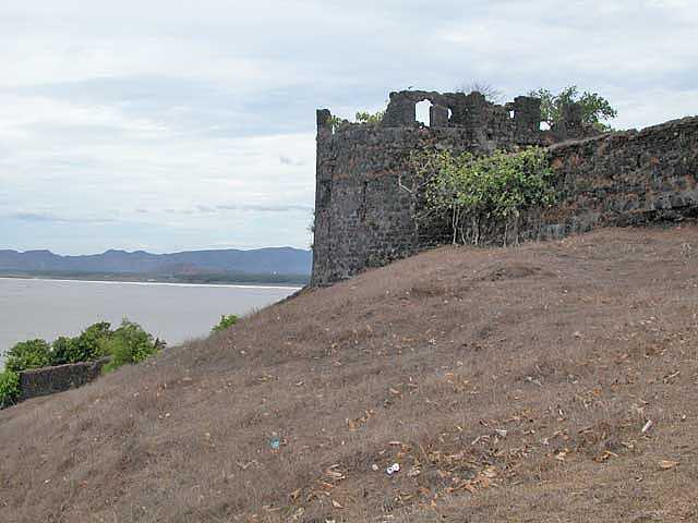
Bandhavgarh Forts: There are about 32 hills and hillocks of Vindhyachal ranges in Bandhavgarh. Among them highest one is about 811mtr. high. At this safe height, on a plateau of 4 sq. km. you find the fort, made in 10th century, on the top, called Bandhavgarh.
Sidhbaba: This place is named after the holy temple of sidhbaba(god of indian worship). This is the most common point from where you can see the tiger near this temple. There is a large marshy meadow behind this temple where wild fauna can be easily witnessed.
Charkadhara: Charkradhara area is a large meadow area inside the park popular for the tiger sighting. During the summers this meadow looks like a open hunting ground for the predators. The charkradhara meadow is surrounded by hilly regions.As the availability of food, water and hiding grass is through out the year, so the wild animals can be easily sighted in this region.
Gopalpur: Gopalpur region is at the north east region of bandhavgarh national park. This region is a marshy area always filled with river water. The aquatic plants and mammals are rich in this area which makes the area suitable for bird watching.
sheesh shaiya bandhavgarhShesh Shaiya: This 65 ft horizontally laid idol of lord vishnu is the origin of river charanganga. The reclining statute of lord vishnu on the seven hooded serpent is the architecture of the past.
Badi Gufa: 'Badi Gufa' in english means the biggest cave. This cave is one of the biggest caves in the bandhavgarh national park region which dates back to the tenth century. This caves is being made by carving the solid rock of sandstone. These caves were the shelters of the army of the king during the medivial period. Now the caves are home to wide variety of bats. The badi gufa is a man made cave not a natural one.
Ketkiha: This wet region inside the bandhavgarh reserve is full of aromatic plant "Pendanus". That why it is also known as pendanus point. The indian name of pendanus plant is kewra. This region is surrounded by the shadows of lofty Jamun and Arjun trees.
Three Cave Pont: The three cave point is visible from the ganesh hillock road. It is a classic example of the prevalent architectural techniques used during the past. The caves now provided the shelter for the wild animals like tiger, sloth bear and even for the leopards.
Sita Mandap: The name of this region resembles the wedding ground of the wife of lord rama. The meaning of Mandap itself wedding ground. The Name of the famous tigress sita is being named after this place. sita is the mother of the most of the tigers and tigress in bandhavgarh reserve area.
Ghorademaon: This is a natural deep george which is a result of geographical processes The water flows continously in this region. You can listen the song of the jungle near this waterbody.
The Photographer's Point: This point is on the way when we drive back from the Route B. This point is the mountain top which gives a panoramic view of the bandhavgarh wildlife sanctuary. The Photography from this point is not allowed for every visitors. Special permission is to be taken from the forest director for the photography purpose.

Andheri Jhiria: The Tigers during the summers spend their afternoon in this region as this area is mostly covered with the shadows of the trees. There is a spring water source in this area from where the water comes out through out the year even during the summer. As the region is darkened by shadows, it is commonly difficult to see the tiger in Andheri Jhiria.
Raj-bahera: The rajbahera region is a marshy meadow which feeds the chitals, sambhar and wild boars. The river damnar originates from Rajbahera. Different species of birds can be easily sighted from this area. You can also see the bandini hills from this region.
Charger's Place: Charger the dominant male in bandhavgarh who ruled the jungle for over a decade. This place was the resting ground of Charger. he died in the year 2000. Charger holds the record to the most photographed male tiger in the world. he died due this natural death. When he died it was very difficult to locate as during the last time of their life they hide in a very secret place where nobody can approach.
Geographically Tiger Reserve forest is spread over Vindhya ranges that spread through Central India and constitute important forest belt sheltering varying variety of flora & fauna. Waterfalls in Vindhya ranges are scenic & popular for its evergreen nature. Vindhay & Satpura ranges are two important forest belts of Central India sheltering a major share of Indian Tiger's population.
How to reach:
Bandhavgarh Tiger Reserve is located in Umaria District of Madhya Pradesh State in India.
From Umaria: It is the nearest largest town connected by road, train and charter planes. Park is just 37kms/45mins from Umaria town.
From Jabalpur: Bandhavgarh is about 190kms from Jabalpur city. Their are 03 different ways to reach Bandhavgarh from Jabalpur i.e via Katni, via Sleemanabad and via Shahpura tribal town. Jabalpur have connectivity with Delhi & Mumbai by Flight and train connectivity with major cities like Agra, Jaipur, Mumbai, Hyderabad, Kolkata etc.
From Katni: This city is important railway junction and is about 100kms/02:30hrs from Bandhavgarh. One can travel by road from Katni to Bandhavgarh via Umaria or Barhi town.
From Khajuraho: It is at a distance of 250kms/05:00hrs is also well connected by road to Bandhavgarh.
Climate & Weather:
The climate of bandhavagrh is a north indian monsoonal. It is mainly characterised by well - defined winters, summers and rains. During the winters the mercury falls upto 2° C in the month of January and during the summers it goes upto 45° C. Average rainfall of 1133 mm, most of which pecipitates during the monsoons.
Best Time to Visit:
Bandhavgarh Tiger Reserve remains open from October to June months for visitors. So one can visit the park at any day during these months. In monsoon, i.e. in the months of July – August – September, Bandhavgarh Park remains closed for visitors.
In first two months, after opening of park, i.e. during October and November, climate remains pleasant as after monsoon departure, we can find greenery everywhere in the forest area with plenty of water-holes. Winter season lasts for 3-months in Bandhavgarh, December – January – February. March & April (first half) are the Spring seasons but day time temperature will make you feel hot as temperature will start reaching 40 degree Celsius in day time. From second-half of April to June, sunlight express his strong presence with heat-waves, dryness in jungle, disappearance of water-holes and a peculiar silence in the forest.
Those who are interested in birding, tiger-sighting along with other mammals sighting, they can visit the park during January – February - March months.
Bandhavgarh History:
The name of the reserve was due to the presence of ancient fort on the mountain. It was belived that lord Rama has gifted the fort to his younger brother lord lakshmana. There is irrefutable evidence of human activity and architectural techniques used in the fort. There are several man made caves with inscription and rock paintings.The archaeological surveys states that bandhavgarh dates back to before chirst period. In the bandhavgarh fort region you will find the written proofs of the bharihas and vakatak dynasties ruled over the land in and around the bandhavgarh region.
Some of the major dynasties which ruled the bandhavgarh area were the Sengars, the kalchuris and the Baghels. The Baghels were believed to be ruled the bandhavgarh fort for the long period.In 1618 AD, the baghels decided that their kingdom had so been extended that bandhavgarh now was in a corner of the kingdom, rather than in the center. So, in days when distances were measured in days rather than in hours, it was deemed fit to shift the capital to rewa in order to save a couple of days. Baghels, with this one stroke were able to save ages for this marvelous land, for they ended up tiger, quite unlimited though ! Once the king and the armies had villages around the fort were deserted and people started to move to greener pastures. Pressures removed, the habitat responded marvelously and a dense, diverse jungle came up, enabling the tiger pyramid to firmly establish itself.
The maharajas of rewa, as historians would later call Baghels, realized that a most marvelous jungle had sprung up around the deserted fort of Bandhavgarh and that large and fierce beasts of strength roamed within its folds. chivairy was the most ferocious of all beasts the Tiger ! So, Bandhavgarh was declared a game reserve with only the royal family having rights of hunting the fierce animal. But, they put the fence rather high, so far as chivalry acknowledgements were concerned at 109 to be exact ! The Rajahs and princes had to shoot down at least 109 tigers to be termed truly chivalrous. So, Rajah Gulab Singh Baghel ended up bringing down 83 tigers during one single year in this pursuit of the magical figure of 109 !
Places of Interest Inside the Park:
Bandhavgarh Ancient Caves: bandhavgarh caves indiaThere are 39 caves in the bandhavgarh forts hill and in surrounding hillocks of about 5 kms.The oldest caves appear to be as ancient as the first century A.D.
Bandhavgarh Forts: There are about 32 hills and hillocks of Vindhyachal ranges in Bandhavgarh. Among them highest one is about 811mtr. high. At this safe height, on a plateau of 4 sq. km. you find the fort, made in 10th century, on the top, called Bandhavgarh.
Sidhbaba: This place is named after the holy temple of sidhbaba(god of indian worship). This is the most common point from where you can see the tiger near this temple. There is a large marshy meadow behind this temple where wild fauna can be easily witnessed.
Charkadhara: Charkradhara area is a large meadow area inside the park popular for the tiger sighting. During the summers this meadow looks like a open hunting ground for the predators. The charkradhara meadow is surrounded by hilly regions.As the availability of food, water and hiding grass is through out the year, so the wild animals can be easily sighted in this region.
Gopalpur: Gopalpur region is at the north east region of bandhavgarh national park. This region is a marshy area always filled with river water. The aquatic plants and mammals are rich in this area which makes the area suitable for bird watching.
sheesh shaiya bandhavgarhShesh Shaiya: This 65 ft horizontally laid idol of lord vishnu is the origin of river charanganga. The reclining statute of lord vishnu on the seven hooded serpent is the architecture of the past.
Badi Gufa: 'Badi Gufa' in english means the biggest cave. This cave is one of the biggest caves in the bandhavgarh national park region which dates back to the tenth century. This caves is being made by carving the solid rock of sandstone. These caves were the shelters of the army of the king during the medivial period. Now the caves are home to wide variety of bats. The badi gufa is a man made cave not a natural one.
Ketkiha: This wet region inside the bandhavgarh reserve is full of aromatic plant "Pendanus". That why it is also known as pendanus point. The indian name of pendanus plant is kewra. This region is surrounded by the shadows of lofty Jamun and Arjun trees.
Three Cave Pont: The three cave point is visible from the ganesh hillock road. It is a classic example of the prevalent architectural techniques used during the past. The caves now provided the shelter for the wild animals like tiger, sloth bear and even for the leopards.
Sita Mandap: The name of this region resembles the wedding ground of the wife of lord rama. The meaning of Mandap itself wedding ground. The Name of the famous tigress sita is being named after this place. sita is the mother of the most of the tigers and tigress in bandhavgarh reserve area.
Ghorademaon: This is a natural deep george which is a result of geographical processes The water flows continously in this region. You can listen the song of the jungle near this waterbody.
The Photographer's Point: This point is on the way when we drive back from the Route B. This point is the mountain top which gives a panoramic view of the bandhavgarh wildlife sanctuary. The Photography from this point is not allowed for every visitors. Special permission is to be taken from the forest director for the photography purpose.
Andheri Jhiria: The Tigers during the summers spend their afternoon in this region as this area is mostly covered with the shadows of the trees. There is a spring water source in this area from where the water comes out through out the year even during the summer. As the region is darkened by shadows, it is commonly difficult to see the tiger in Andheri Jhiria.
Raj-bahera: The rajbahera region is a marshy meadow which feeds the chitals, sambhar and wild boars. The river damnar originates from Rajbahera. Different species of birds can be easily sighted from this area. You can also see the bandini hills from this region.
Charger's Place: Charger the dominant male in bandhavgarh who ruled the jungle for over a decade. This place was the resting ground of Charger. he died in the year 2000. Charger holds the record to the most photographed male tiger in the world. he died due this natural death. When he died it was very difficult to locate as during the last time of their life they hide in a very secret place where nobody can approach.